


Descripción de SailGrib Weather Routing Free
SailGrib WR is an easy to use full-fledged marine navigation app with a very sophisticated and unique weather routing module.
It is designed for recreational cruisers or demanding racers.
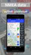
It can calculate the fastest sailing route to your destination along a route with waypoints.
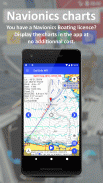
SailGrib WR is the first app to use the Android Navionics sdk that allows you to display your Navionics Boating charts directly in the app without any additional cost.
The app has earned the following distinctions :
- designed for Iridium GO! and Approved by Iridium - january 2015
- Voiles et Voiliers - use it while cruising or racing - November 2014
- Yachting World - "impressive" - July 2014
- Transatlantic race The Cape - Rio 2014 - The Sun Fast 3200 Yolo winner in class 2
- Fastnet 2015 - The JPK1010 Nautistock.com winner in IRC3
- Tour de Corse 2016 - The Sun Fast 3200 Hokua winner in IRC4 and 3rd in IRC Overall
- Spi Ouest France 2017 - The JPK 1080 LSResa winner in IRC double-handed
It now includes:
- free download of all NOAA marine raster charts
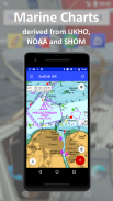
- in app purchase of marine raster charts atlases derived from UKHO, SHOM and NOAA marine charts
- a WiFi NMEA interface
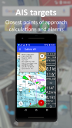
- an AIS module
- a navigation panel
- a instrument panel
- the option to load custom charts
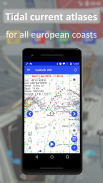
- a full set of atlases of tidal currents for all the European coasts. A SailGrib WR exclusivity
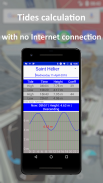
- a tide module which calculates and displays tides level predictions around the world
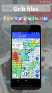
- the NOAA models:
- GFS 0.25°, 0.50° and 1.00°
- NAM and NAM Nest for the continental US
- WW3 global waves
- the Météo France models:
- Arpege - Global 0.5°
- Arpege - Europe - High Resolution 0.1°
- Arome - France - Ultra High Resolution 0.025°
- the oceanic and coastal current models from Mercator Ocean.
- a virtual regatta option to help you win games.
In SailGrib WR, you can specify for your weather routing amongst other parameters:
- the wind grib file: SailGrib WR includes the regular SailGrib features.
- the start, the destination points and intermediary waypoints
- the departure date and time,
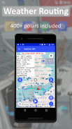
- the speed polar file of your boat. SailGrib WR uses regular Maxsea polar files (.pol extension)
SailGrib WR includes a set of more than 300 polar files for different sailboats.
- wind limits up and downwind
- minimum upwind angle for comfort while cruising
- night efficiency loss for cruising
- mixed routing: use your engine if you are too slow sailing.
- the current
The Free version is limited to:
– 2 days of GFS 0.50° forecast
– 1 day of tidal forecast
– 50 NM routings
– no atlas of tidal currents
– no navigation panel
– no displaying of Navionics charts
You can subscribe to the Premium option for 1 month, 1 year or for life to get all these functionalities.
Important note:
Grib files are computer-generated forecast files which are sent without review, and are offered on an as-is basis. There is no assurance that the data is accurate or correct. By using such data, you acknowledge and agree to these limitations.
The weather routing module is for planning purpose only.
The maps usedeither in navigation or by the weather routing algorithm might be very coarse and for example might not include all the islands.
The Location used by the navigation module migt be inacurate.
By using these maps, these data and this algorithm you agree to these limitations and assume all the responsibility for their use.
SailGrib WR es una aplicación de navegación marítima fácil de usar con un módulo de enrutamiento meteorológico único y muy sofisticado.
Está diseñado para cruceros recreativos o corredores exigentes.
Puede calcular la ruta de navegación más rápida a su destino a lo largo de una ruta con puntos de referencia.
SailGrib WR es la primera aplicación que usa el dispositivo Android Navionics sdk que le permite mostrar sus gráficos de navegación Navionics directamente en la aplicación sin ningún costo adicional.
La aplicación ha ganado las siguientes distinciones:
- Diseñado para Iridium GO! y aprobado por Iridium - enero 2015
- Voiles et Voiliers: utilícelo mientras navega o compite con carreras - Noviembre de 2014
- Yachting World - "impresionante" - Julio 2014
- Carrera transatlántica The Cape - Rio 2014 - The Sun Fast 3200 Yolo ganador en la clase 2
- Fastnet 2015 - El ganador de JPK1010 Nautistock.com en IRC3
- Tour de Corse 2016 - The Sun Fast 3200 Hokua, ganador en IRC4 y tercero en IRC general
- Spi Ouest France 2017 - El ganador del JPK 1080 LSResa en IRC de doble mano
Ahora incluye:
- Descarga gratuita de todas las cartas ráster marinas de NOAA.
- en la aplicación de compra de atlas de cartas ráster marinas derivadas de cartas marinas UKHO, SHOM y NOAA
- una interfaz WiFi NMEA
- un módulo AIS
- un panel de navegación
- un panel de instrumentos
- La opción de cargar gráficos personalizados.
- un conjunto completo de atlas de corrientes de marea para todas las costas europeas. Una exclusividad de SailGrib WR
- un módulo de mareas que calcula y muestra las predicciones de nivel de mareas en todo el mundo
- Los modelos NOAA:
- GFS 0.25 °, 0.50 ° y 1.00 °
- NAM y NAM Nest para los Estados Unidos continentales.
- WW3 olas globales
- Los modelos de Météo France:
- Arpege - Global 0.5 °
- Arpege - Europa - Alta Resolución 0.1 °
- Arome - Francia - Ultra alta resolución 0.025 °
- Los modelos de corrientes oceánicas y costeras de Mercator Ocean.
- una opción de regata virtual para ayudarte a ganar juegos.
En SailGrib WR, puede especificar para su ruta del clima entre otros parámetros:
- el archivo wind grib: SailGrib WR incluye las funciones regulares de SailGrib.
- El inicio, los puntos de destino y los puntos intermedios.
- la fecha y hora de salida,
- El archivo polar de velocidad de tu barco. SailGrib WR utiliza archivos polares de Maxsea normales (extensión .pol)
SailGrib WR incluye un conjunto de más de 300 archivos polares para diferentes veleros.
- Límites de viento arriba y viento abajo.
- ángulo mínimo contra el viento para mayor comodidad durante la navegación
- Pérdida de eficiencia nocturna para cruceros.
- Rutas mixtas: usa tu motor si estás navegando muy lento.
- la corriente
La versión gratuita está limitada a:
- 2 días de pronóstico GFS 0.50 °
- 1 día de pronóstico de mareas
- 50 rutas de NM
- No hay atlas de corrientes de marea.
- sin panel de navegación
- no se muestran las cartas de Navionics
Puede suscribirse a la opción Premium durante 1 mes, 1 año o de por vida para obtener todas estas funcionalidades.
Nota IMPORTANTE:
Los archivos de Grib son archivos de pronóstico generados por computadora que se envían sin revisión y se ofrecen tal como están. No hay seguridad de que los datos sean precisos o correctos. Al utilizar dichos datos, usted reconoce y acepta estas limitaciones.
El módulo de enrutamiento del tiempo es solo para fines de planificación.
Los mapas utilizados en la navegación o por el algoritmo de enrutamiento meteorológico pueden ser muy toscos y, por ejemplo, pueden no incluir todas las islas.
La ubicación utilizada por el módulo de navegación puede ser incorrecta.
Al utilizar estos mapas, estos datos y este algoritmo, acepta estas limitaciones y asume toda la responsabilidad de su uso.
SailGrib Weather Routing Free - Versión 7.9
(23-02-2024)SailGrib Weather Routing Free - Información de APK
Version de la app: 7.9Paquete: com.sailgrib_wrApps en la misma categoría
Quizá también te interese...


